
Jerusalem After the Six-Day War
Cite this page
Israel NOWlej (2027), MAP-019, pp. 40 to 41, israelnowlej.com/map-019
Short address: israelnowlej.com/map-019
Text of this page
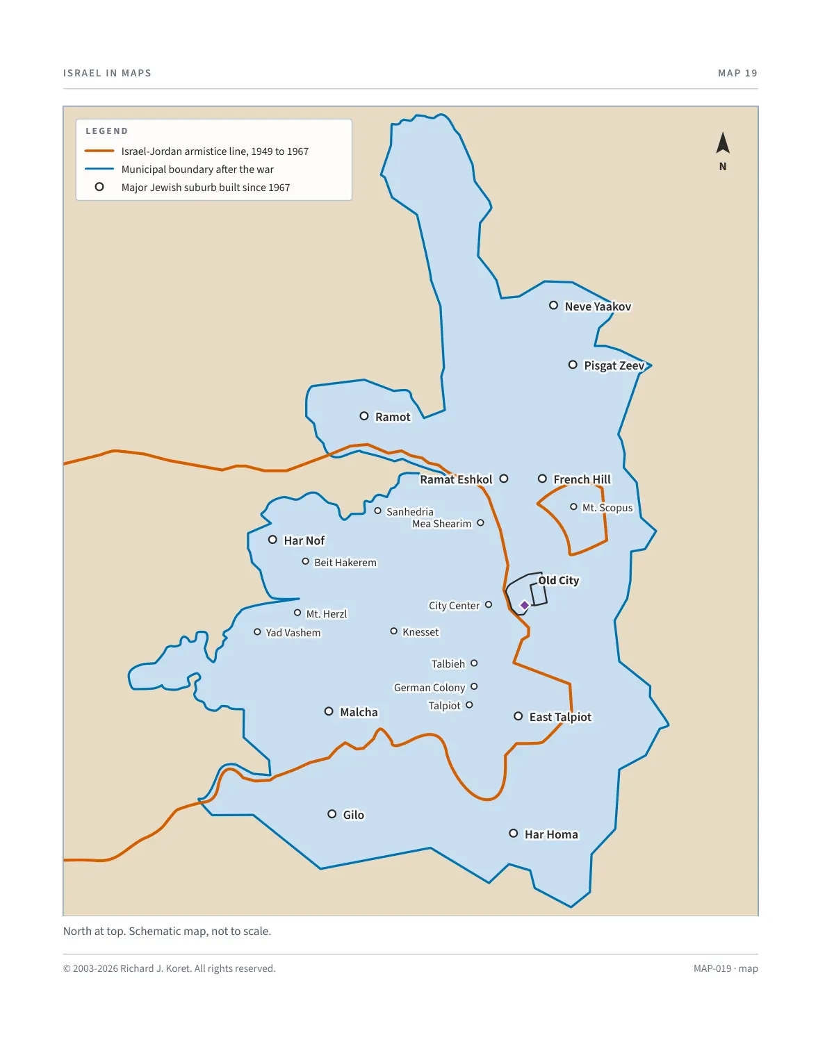
MAP 19
Neve Yaakov Neve Yaakov
Pisgat Zeev Pisgat Zeev
Ramot Ramot
Ramat Eshkol Ramat Eshkol French Hill French Hill
Har Nof Har Nof
Malcha Malcha East Talpiot East Talpiot
Gilo Gilo
Har Homa Har Homa
Sanhedria Sanhedria
Mea Shearim Mea Shearim
City Center City Center
Knesset Knesset
Talbieh Talbieh
German Colony German Colony
Talpiot Talpiot
Beit Hakerem Beit Hakerem
Mt. Herzl Mt. Herzl
Yad Vashem Yad Vashem
Mt. Scopus Mt. Scopus
Old City Old City
L E G E N D
Israel-Jordan armistice line, 1949 to 1967
Municipal boundary after the war
Major Jewish suburb built since 1967
N
North at top. Schematic map, not to scale.
MAP-019 · map
HISTORICAL MAPS
MAP 19 Jerusalem After the Six-Day War
June 27, 1967
In the weeks following the Six-Day War, Israel moved swiftly to solidify its connection to the newly reunited city of Jerusalem. On June 27, 1967, the Israeli Knesset (Parliament) passed a law extending Israeli jurisdiction to all areas of Jerusalem captured during the war, formally integrating eastern Jerusalem into the state. This legislation underscored the city’s deep historical, religious, and cultural significance to the Jewish people, ensuring it remained united under Israeli governance.
The next day, the municipal boundaries of Jerusalem were expanded to include neighborhoods and sites of critical importance. The expanded city now stretches from Atarot and Neve Yaakov in the north to Gilo in the south, integrating areas such as the Old City, home to the Western Wall, Temple Mount, and other landmarks. This move reaffirmed Jerusalem as Israel’s largest city both in population and area.
As of 2023, Jerusalem’s population stands at approximately 985,000, with about 62% Jewish residents and 38% Arab residents, including Muslims and Christians. The city covers an area of 125 square kilometers (48 square miles).
KEY FACTS
June 27, 1967 The Knesset extends Israeli jurisdiction to all areas of Jerusalem captured in the war.
June 28, 1967 The municipal boundaries are expanded.
Extent From Atarot and Neve Yaakov in the north to Gilo in the south.
Population, 2023 About 985,000, roughly 62% Jewish and 38% Arab.
Area 125 square kilometers (48 square miles).
MAP019 Open on your phone $.- ’)*2’ % *(„( +›
Corrections: none recorded. This is the current version. The 2027 print edition copy is at israelnowlej.com/2027/map-019.