
Israel Today
Cite this page
Israel NOWlej (2027), MAP-001, pp. 4 to 5, israelnowlej.com/map-001
Short address: israelnowlej.com/map-001
Text of this page
MAP 1
M E D I T E R R A N E A N
S E A
L E B A N O N
S Y R I A
J O R D A N
E G Y P T
S I N A I P E N I N S U L A
S A U D I A R A B I A
Mt. Hermon
GOLAN
HEIGHTS
SAMARIA SAMARIA
JUDEA JUDEA
G A Z A
Dead Sea
Haifa
Nazareth
Safed
Tiberias
Afula
Herzliya
Tel Aviv-Jaffa
Ashdod
Ashkelon
Jerusalem Jerusalem
Beersheba
Eilat Eilat
Amman Amman
Damascus Damascus
Jenin Jenin
Nablus Nablus
Ramallah Ramallah
Jericho Jericho
Bethlehem Bethlehem
Hebron Hebron
Ariel Ariel
Maale Adumim Maale Adumim
Efrat Efrat
Kiryat Arba Kiryat Arba
L E G E N D
Israel, 1949 lines
Held since 1967 (Golan, Area C)
Area B, Palestinian civil control
Area A, and Gaza west of the line
Gaza held by Israel
Yellow Line, Gaza
National border
International border today
1949 armistice line
Cease-fire line
Principal city
N
100 km
62 mi
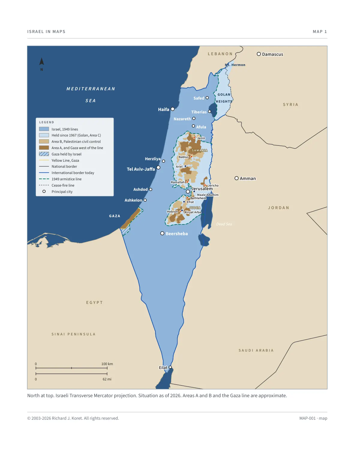
North at top. Israeli Transverse Mercator projection. Situation as of 2026. Areas A and B and the Gaza line are approximate.
MAP-001 · map
HISTORICAL MAPS
MAP 1 Israel Today
Borders, the lines of 1949 and principal cities
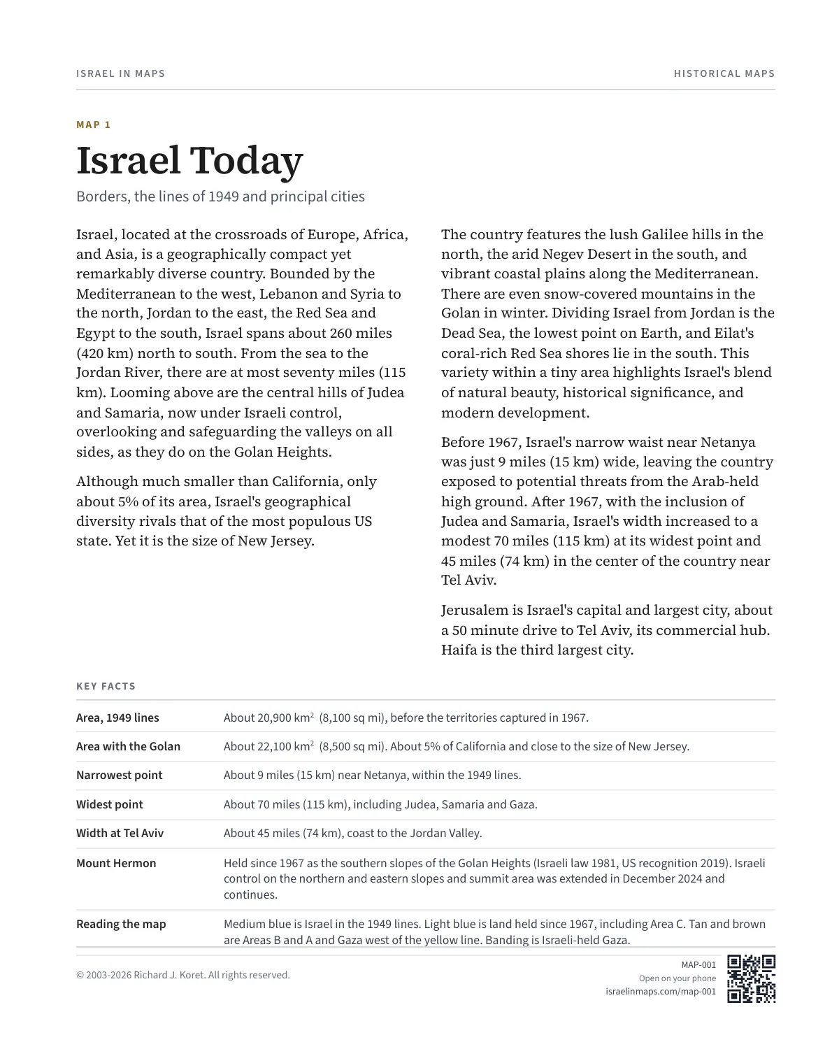
Israel, located at the crossroads of Europe, Africa, and Asia, is a geographically compact yet remarkably diverse country. Bounded by the Mediterranean to the west, Lebanon and Syria to the north, Jordan to the east, the Red Sea and Egypt to the south, Israel spans about 260 miles (420 km) north to south. From the sea to the Jordan River, there are at most seventy miles (115 km). Looming above are the central hills of Judea and Samaria, now under Israeli control, overlooking and safeguarding the valleys on all sides, as they do on the Golan Heights.
Although much smaller than California, only about 5% of its area, Israel's geographical diversity rivals that of the most populous US state. Yet it is the size of New Jersey.
The country features the lush Galilee hills in the north, the arid Negev Desert in the south, and vibrant coastal plains along the Mediterranean. There are even snow-covered mountains in the Golan in winter. Dividing Israel from Jordan is the Dead Sea, the lowest point on Earth, and Eilat's coral-rich Red Sea shores lie in the south. This variety within a tiny area highlights Israel's blend of natural beauty, historical significance, and modern development.
Before 1967, Israel's narrow waist near Netanya was just 9 miles (15 km) wide, leaving the country exposed to potential threats from the Arab-held high ground. After 1967, with the inclusion of Judea and Samaria, Israel's width increased to a modest 70 miles (115 km) at its widest point and 45 miles (74 km) in the center of the country near Tel Aviv.
Jerusalem is Israel's capital and largest city, about a 50 minute drive to Tel Aviv, its commercial hub. Haifa is the third largest city.
KEY FACTS
Area, 1949 lines About 20,900 km² (8,100 sq mi), before the territories captured in 1967.
Area with the Golan About 22,100 km² (8,500 sq mi). About 5% of California and close to the size of New Jersey.
Narrowest point About 9 miles (15 km) near Netanya, within the 1949 lines.
Widest point About 70 miles (115 km), including Judea, Samaria and Gaza.
Width at Tel Aviv About 45 miles (74 km), coast to the Jordan Valley.
Mount Hermon Held since 1967 as the southern slopes of the Golan Heights (Israeli law 1981, US recognition 2019). Israeli control on the northern and eastern slopes and summit area was extended in December 2024 and continues.
Reading the map Medium blue is Israel in the 1949 lines. Light blue is land held since 1967, including Area C. Tan and brown are Areas B and A and Gaza west of the yellow line. Banding is Israeli-held Gaza.
MAP001 Open on your phone $.- ’)*2’ % *(„( +›
Corrections: none recorded. This is the current version. The 2027 print edition copy is at israelnowlej.com/2027/map-001.