
Zion Terrain
Cite this page
Israel NOWlej (2027), MAP-002, pp. 6 to 7, israelnowlej.com/map-002
Short address: israelnowlej.com/map-002
Text of this page
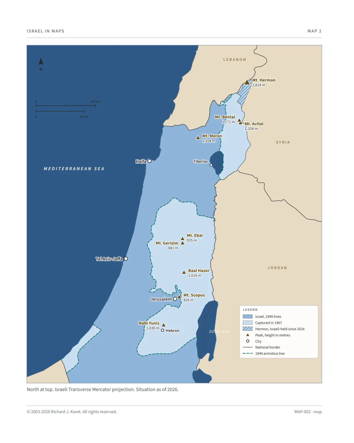
MAP 2
M E D I T E R R A N E A N S E A
L E B A N O N
S Y R I A
J O R D A N
DEAD SEA
Haifa Haifa
Tel Aviv-Jaffa Tel Aviv-Jaffa
Jerusalem Jerusalem
Tiberias Tiberias
Hebron Hebron
Mt. Hermon Mt. Hermon 2,814 m 2,814 m
Mt. Meron Mt. Meron 1,204 m 1,204 m
Mt. Avital Mt. Avital 1,204 m 1,204 m
Mt. Bental Mt. Bental
1,171 m 1,171 m
Baal Hazor Baal Hazor 1,016 m 1,016 m
Nabi Yunis Nabi Yunis
1,030 m 1,030 m
Mt. Ebal Mt. Ebal 935 m 935 m Mt. Gerizim Mt. Gerizim
881 m 881 m
Mt. Scopus Mt. Scopus 826 m 826 m
L E G E N D
Israel, 1949 lines
Captured in 1967
Hermon, Israeli-held since 2024
Peak, height in metres
City
National border
1949 armistice line
N
50 km
25 mi
North at top. Israeli Transverse Mercator projection. Situation as of 2026.
MAP-002 · map
HISTORICAL MAPS
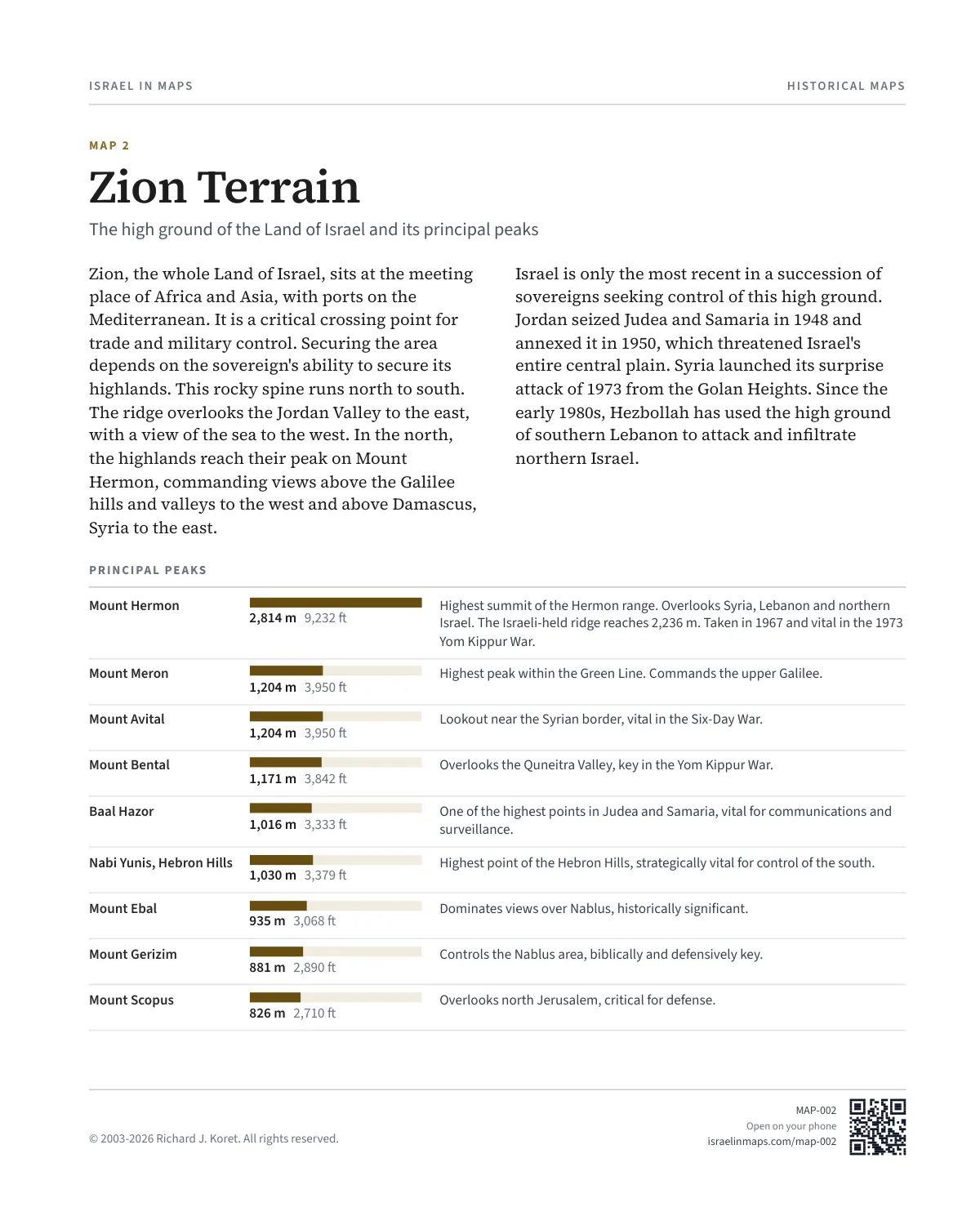
MAP 2 Zion Terrain
The high ground of the Land of Israel and its principal peaks
Zion, the whole Land of Israel, sits at the meeting place of Africa and Asia, with ports on the Mediterranean. It is a critical crossing point for trade and military control. Securing the area depends on the sovereign's ability to secure its highlands. This rocky spine runs north to south. The ridge overlooks the Jordan Valley to the east, with a view of the sea to the west. In the north, the highlands reach their peak on Mount Hermon, commanding views above the Galilee hills and valleys to the west and above Damascus, Syria to the east.
Israel is only the most recent in a succession of sovereigns seeking control of this high ground. Jordan seized Judea and Samaria in 1948 and annexed it in 1950, which threatened Israel's entire central plain. Syria launched its surprise attack of 1973 from the Golan Heights. Since the early 1980s, Hezbollah has used the high ground of southern Lebanon to attack and infiltrate northern Israel.
PRINCIPAL PEAKS
Mount Hermon
2,814 m 9,232 ft Highest summit of the Hermon range. Overlooks Syria, Lebanon and northern Israel. The Israeli-held ridge reaches 2,236 m. Taken in 1967 and vital in the 1973 Yom Kippur War.
Mount Meron
1,204 m 3,950 ft Highest peak within the Green Line. Commands the upper Galilee.
Mount Avital
1,204 m 3,950 ft Lookout near the Syrian border, vital in the Six-Day War.
Mount Bental
1,171 m 3,842 ft Overlooks the Quneitra Valley, key in the Yom Kippur War.
Baal Hazor
1,016 m 3,333 ft One of the highest points in Judea and Samaria, vital for communications and surveillance.
Nabi Yunis, Hebron Hills
1,030 m 3,379 ft Highest point of the Hebron Hills, strategically vital for control of the south.
Mount Ebal
935 m 3,068 ft Dominates views over Nablus, historically significant.
Mount Gerizim
881 m 2,890 ft Controls the Nablus area, biblically and defensively key.
Mount Scopus
826 m 2,710 ft Overlooks north Jerusalem, critical for defense.
MAP002 Open on your phone $.- ’)*2’ % *(„( +›
Corrections: none recorded. This is the current version. The 2027 print edition copy is at israelnowlej.com/2027/map-002.