
Kingdoms of David and Solomon
Cite this page
Israel NOWlej (2027), MAP-004, pp. 10 to 11, israelnowlej.com/map-004
Short address: israelnowlej.com/map-004
Text of this page
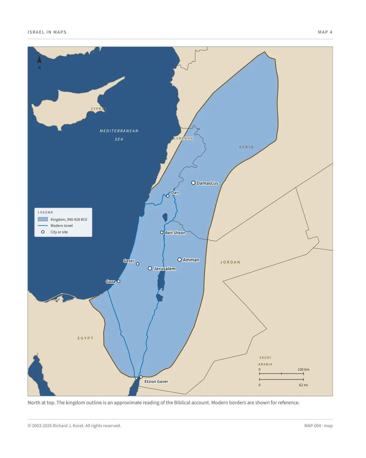
MAP 4
M E D I T E R R A N E A N
S E A
S Y R I A
L E B A N O N L E B A N O N
J O R D A N
E G Y P T
SAUDI
ARABIA
CY P R US
Damascus Damascus
Dan Dan
Beit Shean Beit Shean
Amman Amman
Jerusalem Jerusalem
Gezer Gezer
Gaza Gaza
Etzion Gaver Etzion Gaver
L E G E N D
Kingdom, 990-928 BCE
Modern Israel
City or site
N
100 km
62 mi
North at top. The kingdom outline is an approximate reading of the Biblical account. Modern borders are shown for reference.
MAP-004 · map
HISTORICAL MAPS
MAP 4 Kingdoms of David and Solomon
990 to 928 BCE, with modern borders for reference
King David ruled Israel for 22 years, establishing Jerusalem as the nation’s eternal capital and the spiritual center of Jewish life. His military campaigns united the tribes of Israel and expanded the kingdom’s territory to include large portions of what is now Israel, Judea and Samaria, and portions of neighboring regions. David’s leadership laid the groundwork for a centralized government, a standing army, and a unified national identity. His son Solomon succeeded him, ruling till 928 BCE.
Solomon is celebrated for his wisdom, reforms and construction of the First Temple in Jerusalem. The Temple he built became the focal point of Jewish worship, a symbol of Israel’s covenant with God.
The Bible records that Solomon “ruled over all the kingdoms west of the Euphrates River from Tiphsah to Gaza; he was at peace with all his neighbors” (I Kings 4:24). His diplomatic efforts and trade alliances brought wealth and stability to the kingdom, marking an era of prosperity and growth.
The period was the apex of ancient Israel’s geopolitical influence, establishing the continuous Jewish historical connection to the land of Israel and to Jerusalem, its capital for most of the time.
NOTES
Period 990 to 928 BCE. David ruled for 22 years and his son Solomon succeeded him.
Jerusalem Capital of the kingdom and the site of the First Temple built by Solomon.
Etzion Gaver Port at the head of the Gulf of Eilat, the kingdom’s southern limit on this map.
Damascus Capital of Aram, inside the northern reach of the outline.
Reading the map Gold shows the approximate extent of the kingdom as the Biblical account describes it. The blue line is the border of modern Israel. Borders of neighboring states are modern.
MAP004 Open on your phone $.- ’)*2’ % *(„( +›
Corrections: none recorded. This is the current version. The 2027 print edition copy is at israelnowlej.com/2027/map-004.