
Israel’s Narrow Waist
Cite this page
Israel NOWlej (2027), MAP-014, pp. 30 to 31, israelnowlej.com/map-014
Short address: israelnowlej.com/map-014
Text of this page
MAP 14
M E D I T E R R A N E A N
S E A
J O R D A N
SAMARIA SAMARIA
JUDEA JUDEA
DEAD SEA DEAD SEA
10 km 10 km
15 km 15 km
18 km 18 km
6 km 6 km
17 km 17 km
11 km 11 km
16 km 16 km
Afula Afula
Netanya Netanya
Tel Aviv-Jaffa Tel Aviv-Jaffa
Ben Gurion Airport Ben Gurion Airport
Jerusalem Jerusalem
Ashkelon Ashkelon
Beer Sheba Beer Sheba
Jenin Jenin
Tulkarm Tulkarm
Nablus Nablus
Kalkilya Kalkilya
Hebron Hebron
Ariel Ariel
Givat Zeev Givat Zeev
Modiin Illit Modiin Illit
Maale Adumim Maale Adumim
Beitar Illit Beitar Illit
Efrat Efrat
Kiryat Arba Kiryat Arba
Ramallah Ramallah
Beit Hanoun Beit Hanoun
L E G E N D
Israel, 1949 lines
Jordan-held, now Area C
Jordan-held, now Area B
Jordan-held, now Area A
Egypt-held
Israeli city, 1949 lines
Israeli community
Arab city
Distance to the line
N
20 km
12 mi
North at top. Distances are approximate and measured to the 1949 armistice lines.
MAP-014 · map
HISTORICAL MAPS
MAP 14 Israel’s Narrow Waist
1949 to 1967
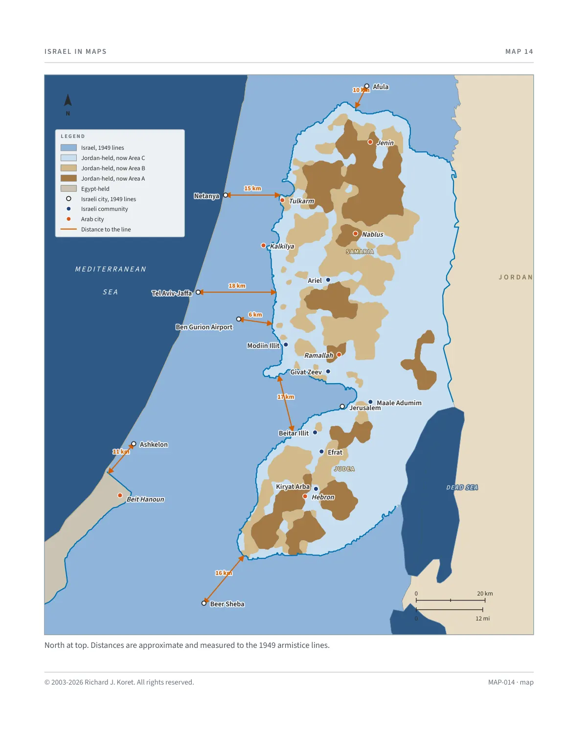
Between the years 1949 and 1967, the Kingdom of Jordan ruled the Judea and Samaria highlands. Israel’s ‘waistline’ in the Sharon region was extremely narrow, totaling a mere 15 km (9 mi.) between Tulkarm and Netanya.
These were cease-fire lines rather than permanent borders, considered to be militarily indefensible, especially in light of the area’s topography, which left Israel in the plains while the Arab armies and terror factions, controlled the dominating high ground.
The Israeli Foreign Minister at that time, Abba Eban, used to describe these lines as ‘Auschwitz boundaries’.
DISTANCES TO THE LINES
Netanya to Tulkarm The narrowest point, about 15 km (9 mi).
Afula About 10 km (6 mi) from the line.
Tel Aviv About 18 km (11 mi) from the line.
Ben Gurion About 6 km (4 mi) from the line.
Ashkelon About 11 km (7 mi) from the line.
Beer Sheba About 16 km (10 mi) from the line.
Jerusalem corridor About 17 km (10 mi) wide.
MAP014 Open on your phone $.- ’)*2’ % *(„( +›
Corrections: none recorded. This is the current version. The 2027 print edition copy is at israelnowlej.com/2027/map-014.