
Jerusalem Before the Six-Day War
Cite this page
Israel NOWlej (2027), MAP-015, pp. 32 to 33, israelnowlej.com/map-015
Short address: israelnowlej.com/map-015
Text of this page
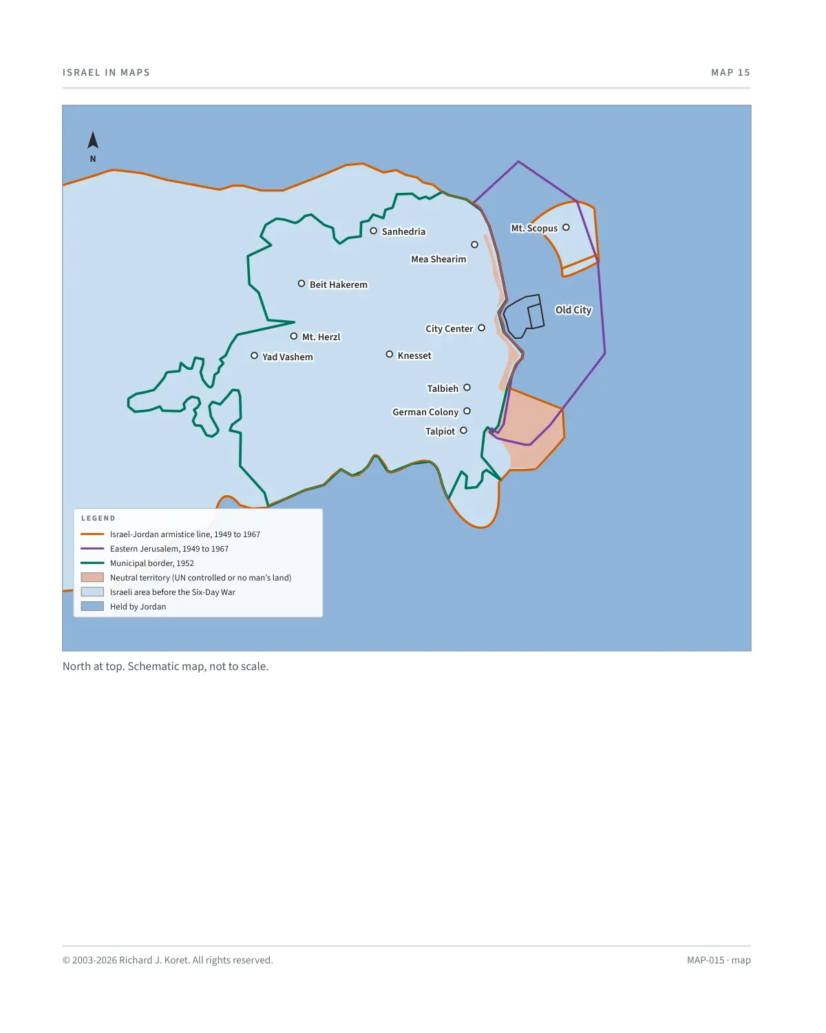
MAP 15
Sanhedria Sanhedria
Mea Shearim Mea Shearim
City Center City Center
Knesset Knesset
Talbieh Talbieh
German Colony German Colony
Talpiot Talpiot
Beit Hakerem Beit Hakerem
Mt. Herzl Mt. Herzl
Yad Vashem Yad Vashem
Mt. Scopus Mt. Scopus
Old City Old City
L E G E N D
Israel-Jordan armistice line, 1949 to 1967
Eastern Jerusalem, 1949 to 1967
Municipal border, 1952
Neutral territory (UN controlled or no man’s land)
Israeli area before the Six-Day War
Held by Jordan
N
North at top. Schematic map, not to scale.
MAP-015 · map
HISTORICAL MAPS
MAP 15 Jerusalem Before the Six-Day War
June 4, 1967
At the end of the War of Independence, Jerusalem was divided between Israel and Jordan. Armistice lines were determined in November 1948. The area around Armon Hanatziv was used as UN territory, and Mount Scopus became an Israeli enclave containing the Hebrew University, Hadassah Hospital and, officially, the village of Issawiyya. This map was adopted in April 1949 in an armistice agreement signed in Rhodes. The westernmost point between the two parts of the divided city was at the edge of the Musrara neighborhood, near the Mandelbaum Gate.
KEY POINTS
November 1948 Armistice lines are determined in divided Jerusalem.
April 1949 The armistice agreement is signed in Rhodes and the map is adopted.
Mount Scopus An Israeli enclave with the Hebrew University and Hadassah Hospital.
Armon Hanatziv The area is used as UN territory.
Mandelbaum Gate Near the westernmost point between the two parts of the city, at the edge of Musrara.
MAP015 Open on your phone $.- ’)*2’ % *(„( +›
Corrections: none recorded. This is the current version. The 2027 print edition copy is at israelnowlej.com/2027/map-015.