
Setting the Southern Border
Cite this page
Israel NOWlej (2027), MAP-008, pp. 18 to 19, israelnowlej.com/map-008
Short address: israelnowlej.com/map-008
Text of this page
MAP 8
El Arish El Arish
Rafah Rafah
Beersheba Beersheba
Kantara Kantara
Kosema Kosema
Bir Gafgafa Bir Gafgafa
Suez Suez
Aqaba Aqaba
A Tur A Tur
Sharm el-Sheikh Sharm el-Sheikh
M E D I T E R R A N E A N S E A
Suez
Canal
Gulf of
Eilat
L E G E N D
Turkish order, 1861
Jennings proposal
British-Turkish agreement, 1906
Border of 1906
Modern Israel border
N
40 km
25 mi
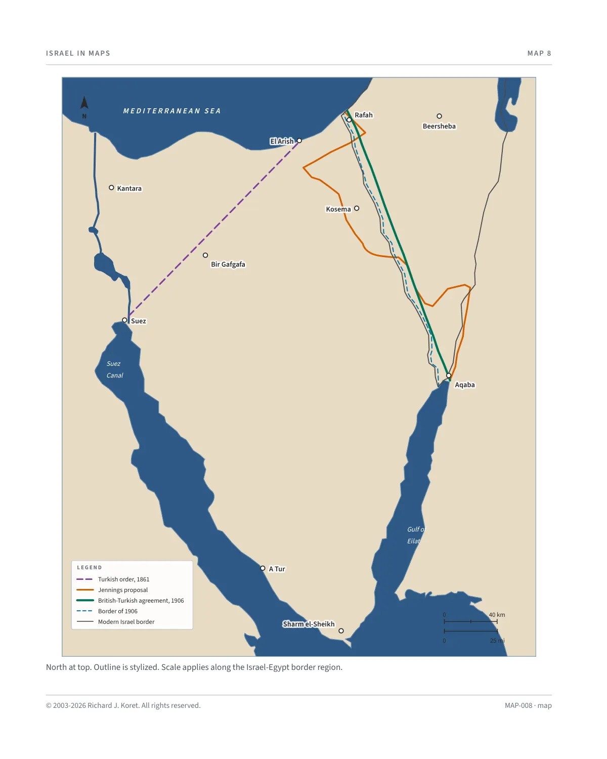
North at top. Outline is stylized. Scale applies along the Israel-Egypt border region.
MAP-008 · map
HISTORICAL MAPS
MAP 8 Setting the Southern Border
Boundary proposals and agreements, 1861 to 1906, with the modern border shown for reference
Great Britain wanted to move the border with the Ottoman Empire, then under strong German influence, further from the Suez Canal. In 1892, the Turks agreed to allow Egyptian guard stations near the Gulf of Eilat. In April 1906, the Turks finally gave in to British pressure.
The firm stand of the commander of the Turkish police station at Um Rashrash, now known as Eilat, played a pivotal role in shaping the modern border between Israel and Egypt in this strategic area, which was vital for access to the Red Sea and trade routes.
Today, the area once patrolled by Ottoman forces forms the southernmost point of Israel and the site of the city of Eilat, a major port and tourist destination. The modern border between Israel and Egypt, finalized through diplomatic agreements, follows this historic line, with Taba marking the frontier checkpoint.
KEY DATES
The Turks agree to allow Egyptian guard stations near the Gulf of Eilat.
April 1906 The Turks finally give in to British pressure.
Um Rashrash Turkish police station, now Eilat. Its commander’s firm stand shaped the border.
Taba Frontier checkpoint on the modern border between Israel and Egypt.
Reading the map Lines show the 1861 order, the Jennings proposal, the 1906 agreement and border, and today’s Israel border for reference.
MAP008 Open on your phone $.- ’)*2’ % *(„( +›
Corrections: none recorded. This is the current version. The 2027 print edition copy is at israelnowlej.com/2027/map-008.