
Formation of the British Mandate
Cite this page
Israel NOWlej (2027), MAP-010, pp. 22 to 23, israelnowlej.com/map-010
Short address: israelnowlej.com/map-010
Text of this page
MAP 10
Jerusalem
Tel Aviv and Jaffa Petah Tikva
Haifa Tiberias
Safed
Rishon LeZion
Rehovot
Hadera
Zikhron Yaakov
M E D I T E R R A N E A N
S E A
S Y R I A
(French Mandate)
I R A Q
S A U D I A R A B I A
E G Y P T
T R A N S J O R D A N PA L E ST I N E
L E G E N D
Boundary of the British Mandate, 1920
Palestine, west of the Jordan
Transjordan, separated 1921
Ceded to Syria, 1923
Ten largest Jewish communities, c. 1922
N
80 km
50 mi
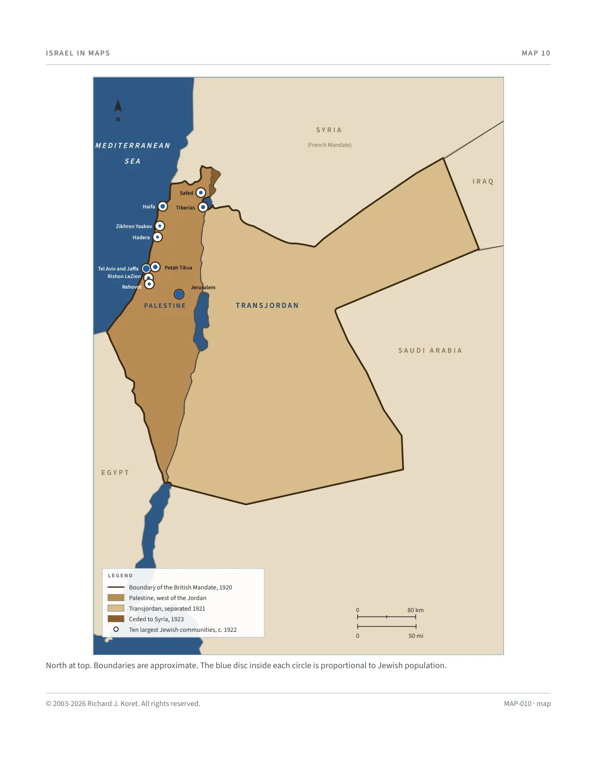
North at top. Boundaries are approximate. The blue disc inside each circle is proportional to Jewish population.
MAP-010 · map
HISTORICAL MAPS
MAP 10 Formation of the British Mandate
1920 to 1923
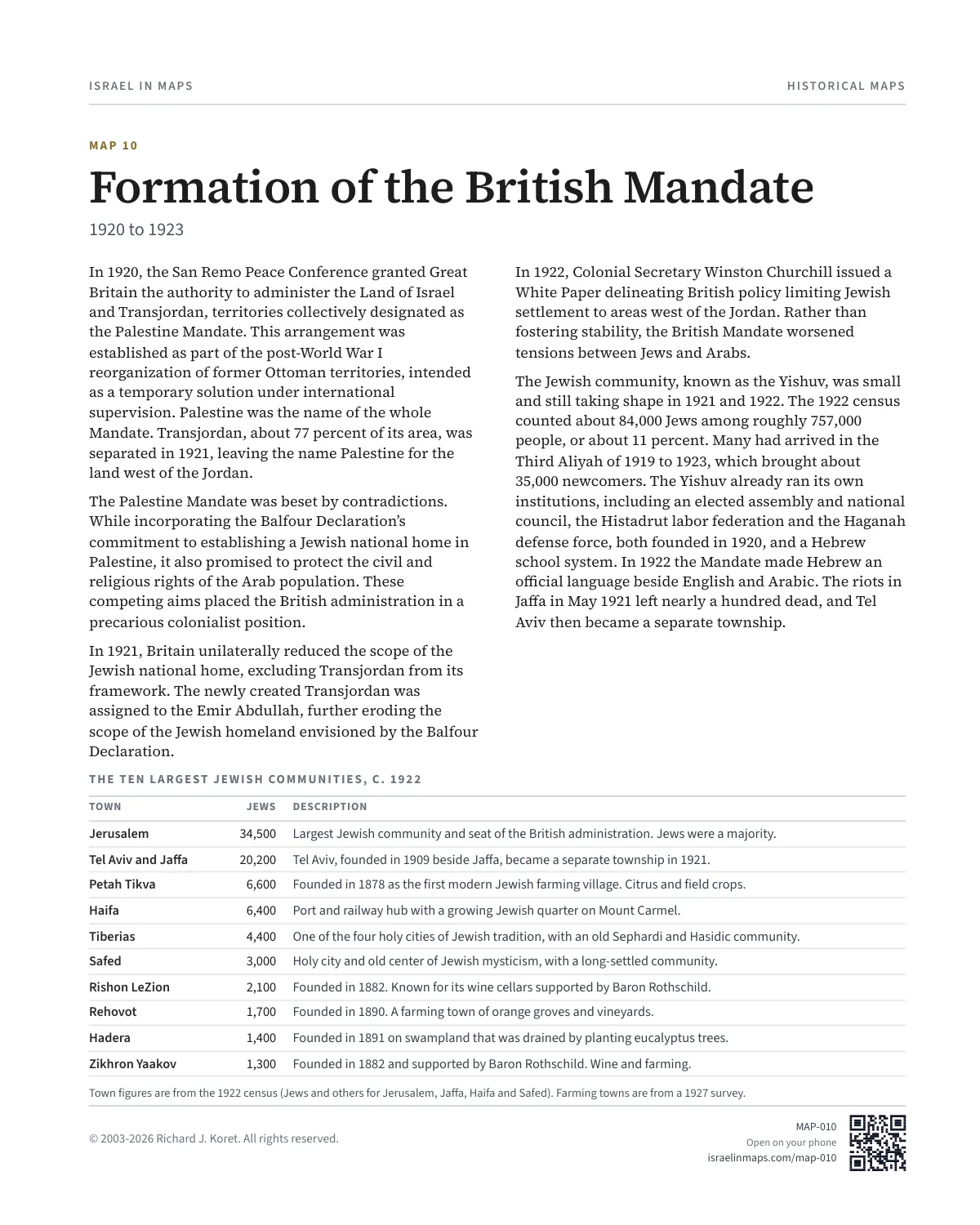
In 1920, the San Remo Peace Conference granted Great Britain the authority to administer the Land of Israel and Transjordan, territories collectively designated as the Palestine Mandate. This arrangement was established as part of the post-World War I reorganization of former Ottoman territories, intended as a temporary solution under international supervision. Palestine was the name of the whole Mandate. Transjordan, about 77 percent of its area, was separated in 1921, leaving the name Palestine for the land west of the Jordan.
The Palestine Mandate was beset by contradictions. While incorporating the Balfour Declaration’s commitment to establishing a Jewish national home in Palestine, it also promised to protect the civil and religious rights of the Arab population. These competing aims placed the British administration in a precarious colonialist position.
In 1921, Britain unilaterally reduced the scope of the Jewish national home, excluding Transjordan from its framework. The newly created Transjordan was assigned to the Emir Abdullah, further eroding the scope of the Jewish homeland envisioned by the Balfour Declaration.
In 1922, Colonial Secretary Winston Churchill issued a White Paper delineating British policy limiting Jewish settlement to areas west of the Jordan. Rather than fostering stability, the British Mandate worsened tensions between Jews and Arabs.
The Jewish community, known as the Yishuv, was small and still taking shape in 1921 and 1922. The 1922 census counted about 84,000 Jews among roughly 757,000 people, or about 11 percent. Many had arrived in the Third Aliyah of 1919 to 1923, which brought about 35,000 newcomers. The Yishuv already ran its own institutions, including an elected assembly and national council, the Histadrut labor federation and the Haganah defense force, both founded in 1920, and a Hebrew school system. In 1922 the Mandate made Hebrew an official language beside English and Arabic. The riots in Jaffa in May 1921 left nearly a hundred dead, and Tel Aviv then became a separate township.
THE TEN LARGEST JEWISH COMMUNITIES, C. 1922
TOWN JEWS DESCRIPTION
Jerusalem 34,500 Largest Jewish community and seat of the British administration. Jews were a majority.
Tel Aviv and Jaffa 20,200 Tel Aviv, founded in 1909 beside Jaffa, became a separate township in 1921.
Petah Tikva 6,600 Founded in 1878 as the first modern Jewish farming village. Citrus and field crops.
Haifa 6,400 Port and railway hub with a growing Jewish quarter on Mount Carmel.
Tiberias 4,400 One of the four holy cities of Jewish tradition, with an old Sephardi and Hasidic community.
Safed 3,000 Holy city and old center of Jewish mysticism, with a long-settled community.
Rishon LeZion 2,100 Founded in 1882. Known for its wine cellars supported by Baron Rothschild.
Rehovot 1,700 Founded in 1890. A farming town of orange groves and vineyards.
Hadera 1,400 Founded in 1891 on swampland that was drained by planting eucalyptus trees.
Zikhron Yaakov 1,300 Founded in 1882 and supported by Baron Rothschild. Wine and farming.
Town figures are from the 1922 census (Jews and others for Jerusalem, Jaffa, Haifa and Safed). Farming towns are from a 1927 survey.
MAP010 Open on your phone $.- ’)*2’ % *(„( +›
Corrections: none recorded. This is the current version. The 2027 print edition copy is at israelnowlej.com/2027/map-010.