
UN Partition Plan
Cite this page
Israel NOWlej (2027), MAP-011, pp. 24 to 25, israelnowlej.com/map-011
Short address: israelnowlej.com/map-011
Text of this page
MAP 11
M E D I T E R R A N E A N
S E A
S Y R I A
L E B A N O N
T R A N S J O R D A N
E G Y P T
DEAD SEA DEAD SEA
Haifa
Tel Aviv
Jaffa
Jerusalem Jerusalem
Beer Sheba Beer Sheba
L E G E N D
Jewish State
Arab State
International Zone
N
50 km
31 mi
North at top. Zone boundaries are approximate.
MAP-011 · map
HISTORICAL MAPS
MAP 11 UN Partition Plan
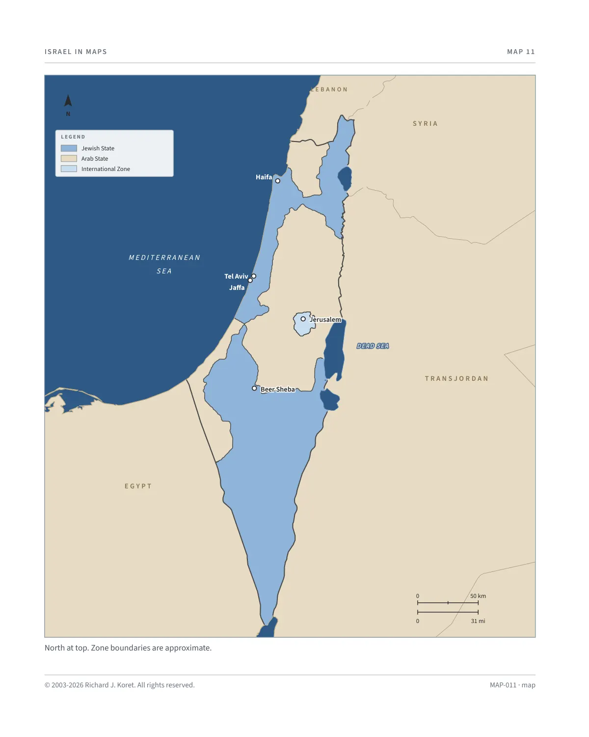
In 1947, facing escalating violence and political unrest, Great Britain turned over administration of Mandatory Palestine to the United Nations. The UN established a committee to propose a solution. After extensive investigations, UNSCOP recommended partitioning the land into separate Jewish and Arab states, with Jerusalem placed under international supervision to preserve its religious significance.
The proposal sparked heated debate. Jewish leaders accepted the plan as a step toward statehood, though not all were satisfied with the borders. Arab leaders and neighboring Arab states rejected the plan, arguing it unfairly allocated land to the Jewish minority.
Despite this, on November 29, 1947, the UN General Assembly approved Resolution 181 by a vote of 33-13, with 10 abstentions. Support came from Western nations, Soviet bloc, and Latin America, while Arab and Muslim-majority states opposed.
The resolution marked a turning point in history, paving the way for the establishment of the State of Israel. It was celebrated by Jews worldwide but condemned by Arab leaders, who vowed to resist its implementation. The UN’s approval of the partition plan set the stage for war.
KEY FACTS
29 November 1947 UN General Assembly adopts Resolution 181 by 33 votes to 13, with 10 abstentions.
Arab State Western Galilee, Judea and Samaria, and a coastal strip from Gaza to the Egyptian border.
International Zone Jerusalem and Bethlehem, under international supervision.
Reading the map Boundaries are approximate. Jewish State, Arab State and International Zone are shown as proposed.
MAP011 Open on your phone $.- ’)*2’ % *(„( +›
Corrections: none recorded. This is the current version. The 2027 print edition copy is at israelnowlej.com/2027/map-011.