
War of Independence Armistice
Cite this page
Israel NOWlej (2027), MAP-012, pp. 26 to 27, israelnowlej.com/map-012
Short address: israelnowlej.com/map-012
Text of this page
MAP 12
M E D I T E R R A N E A N
S E A
S Y R I A
L E B A N O N
J O R D A N
E G Y P T
SAMARIA
JUDEA
Gaza Strip
DEAD SEA DEAD SEA
Haifa Haifa
Tel Aviv Tel Aviv
Jaffa Jaffa
Jerusalem Jerusalem
Beer Sheba Beer Sheba
L E G E N D
Israel, 1949 lines
Area given to Israel
Held by Jordan
Held by Egypt
N
50 km
31 mi
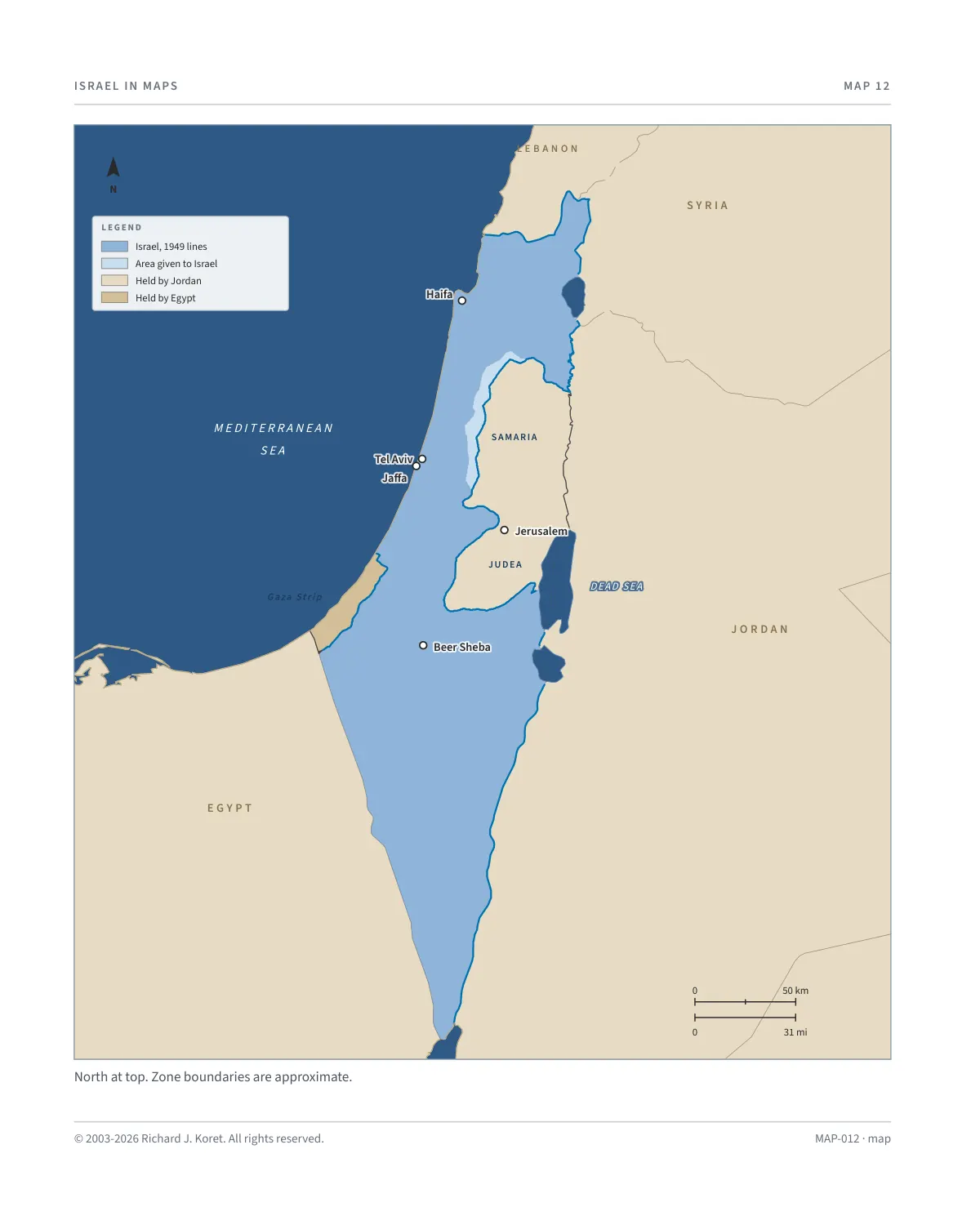
North at top. Zone boundaries are approximate.
MAP-012 · map
HISTORICAL MAPS
MAP 12 War of Independence Armistice Lines
1948 to 1949
The War of Independence began after the UN partition plan in 1947, with Arab militias and Arab states attacking Jewish communities. Following Israel’s declaration of independence on May 14, 1948, armies of Egypt, Transjordan, Syria, Lebanon, and Iraq invaded, aiming to destroy the new state. Despite being outnumbered, Israeli forces defended the nation, securing West Jerusalem, the Negev, and Be’er Sheva, while enduring heavy losses. By war’s end, Israel expanded its territory beyond the UN partition plan.
In 1949, armistice agreements were signed between Israel and Egypt, Jordan, Syria, and Lebanon, with the ‘Green Line’ setting the de facto borders. Jordan controlled Judea and Samaria. Egypt held the Gaza Strip.
The armistice lines were intended to be temporary, with plans for permanent borders set through negotiations. However, Arab states refused to recognize Israel, leaving the lines in place and shaping the region’s geopolitics for decades.
The war transformed the nation’s demography. In 1949, its population of 1,013,900 was 86% Jewish, mostly Holocaust survivors and Jews fleeing persecution in Arab countries. This created a mix of Ashkenazi and Mizrahi communities.
Muslims, Christians, and Druze, made up 14% (around 156,000) of the total. Hundreds of thousands of Arab residents were displaced before or during the war.
KEY FACTS
May 14, 1948 Israel declares independence. Armies of Egypt, Transjordan, Syria, Lebanon and Iraq invade.
Armistice agreements are signed with Egypt, Jordan, Syria and Lebanon. The Green Line sets the de facto borders.
Judea and Samaria Held by Jordan.
Gaza Strip Held by Egypt.
Reading the map The blue line is the armistice line, the Green Line. Smaller zones, such as the demilitarized zones and No Man’s Land in Jerusalem, are too small to show at this scale.
MAP012 Open on your phone $.- ’)*2’ % *(„( +›
Corrections: none recorded. This is the current version. The 2027 print edition copy is at israelnowlej.com/2027/map-012.