
Setting the Northern Border
Cite this page
Israel NOWlej (2027), MAP-009, pp. 20 to 21, israelnowlej.com/map-009
Short address: israelnowlej.com/map-009
Text of this page
MAP 9
Metullah Metullah
Banias Banias
Kuneitra Kuneitra
Safed Safed
Nahariya Nahariya
Acre Acre
Haifa Haifa
Tiberias Tiberias
M E D I T E R R A N E A N
S E A
L E B A N O N
S Y R I A
Sea of
Galilee
L E G E N D
Sykes-Picot line, 1916
French-British agreement, 1920
Border of 1923
Modern Israel
N
20 km
12 mi
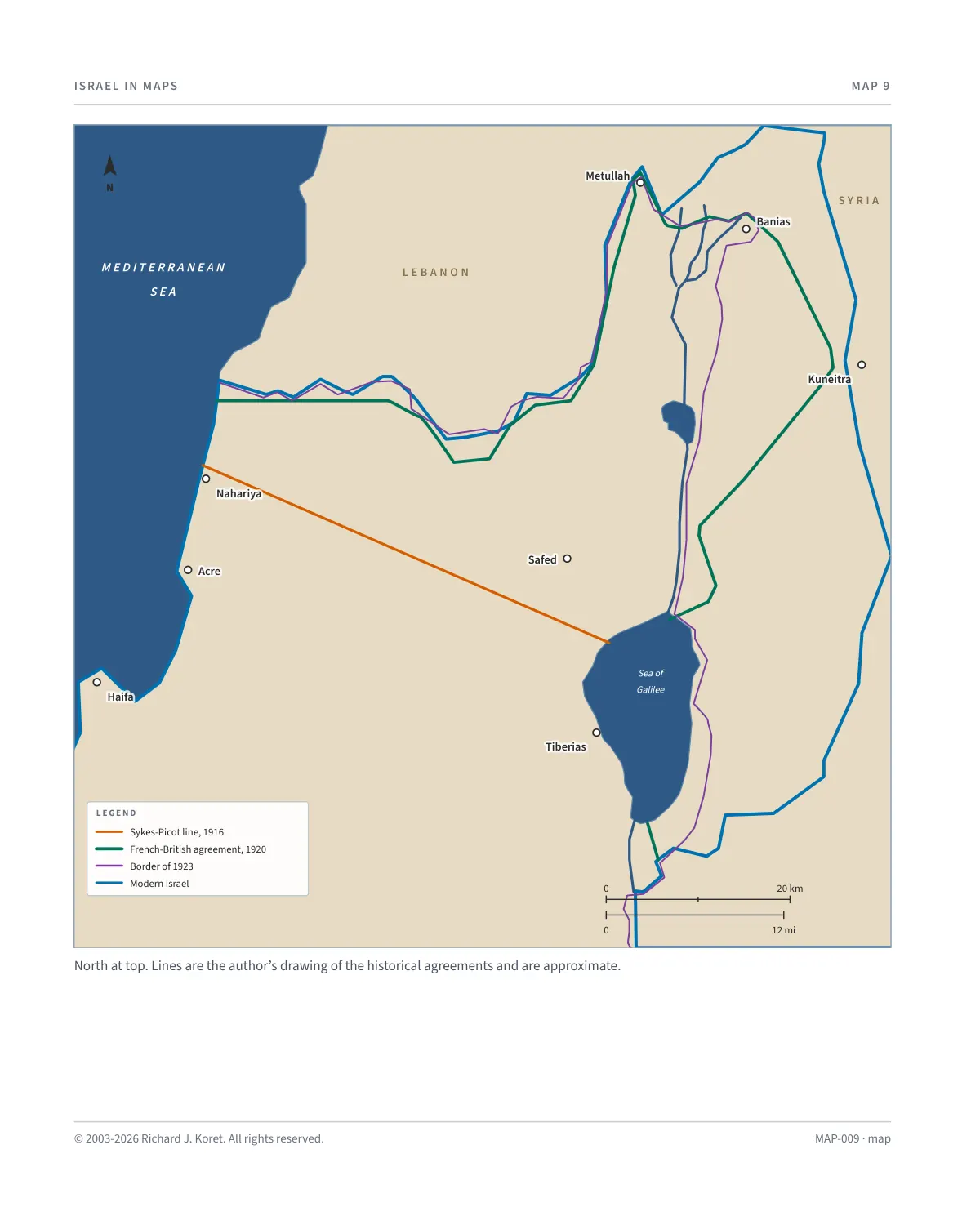
North at top. Lines are the author’s drawing of the historical agreements and are approximate.
MAP-009 · map
HISTORICAL MAPS
MAP 9 Setting the Northern Border
1916 to 1923, with the border of modern Israel for reference
In May 1916, France and Great Britain signed the Sykes-Picot Agreement, in which the claims of both sides to the Levant were set down, determining areas of administration and influence.
Until 1923, the sides were involved in hard bargaining, with the British insisting on control “from Dan to Beer Sheba” and control of its main water sources, the Jordan River and Sea of Galilee.
KEY DATES
May 1916 France and Great Britain sign the Sykes-Picot Agreement. The red line marks the Sykes-Picot line.
The green line marks the French-British agreement of 1920.
The purple line marks the border of 1923, reached after hard bargaining over the Jordan River and the Sea of Galilee.
Reading the map The blue line is the border of modern Israel, for reference. Where lines run together, the colors are drawn one over another.
MAP009 Open on your phone $.- ’)*2’ % *(„( +›
Corrections: none recorded. This is the current version. The 2027 print edition copy is at israelnowlej.com/2027/map-009.